Search Constraints
Search Results
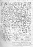
- Description:
- Map. "Map of Ohio and the settled parts of Michigan. 1833" Published by A. Finley Philadelphia and engraved by J.H. Young. Vignette at the bottom of the map "Profile of the Ohio and Erie Canal." Separate black leather hard-cover entitled "Ohio & Michigan".
- Date Issued:
- 1833-01-01T00:00:00Z
- Data Provider:
- Detroit Historical Society
- Collection:
- General History
- Notes:
- This is a section of a map showing the locations of Arbeitskommandos (Allied labor detachments) in the Kingdom of Saxony. The map is coded to identify agricultural labor, industrial labor, work for the state, and . public interest projects. The map is further delineated identifying the Stammlagern (parent camps) where the prisoners were assigned; in this case, the prison camps at Golzern, Koenigsbrueck, and Chemnitz provided the man power for this labor.
- Date Created:
- 1918-01-01T00:00:00Z
- Data Provider:
- Western Michigan University. Libraries