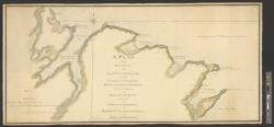
A plan of the sea coast from Gage Point to Cumberland Cape including Dartmouth and Granby Bays with the coal mines in that extent taken from the large survey of the island of Cape Britain survey'd agreable to the orders and instructions of the right honbl
Enclosed in: Holland to Gage, July 2, 1767.; Additional information at left of plan: Drawn for his excellency the honble. Major General Thos. Gage commander in chief of his majesty's forces in America &c by Ensn. George Goldfrap of the 60th Regt.; Identifies ruins of Fort William and various outcrops and burning mines of coal.
The University of Michigan Library provides access to these materials for educational and research purposes. These materials may be under copyright. If you decide to use any of these materials, you are responsible for making your own legal assessment and securing any necessary permission. If you have questions about the collection, please contact the William L. Clements Library: icwcl1ic-umdl-help@umich.edu. If you have concerns about the inclusion of an item in this collection, please contact Library IT: libraryit-info@umich.edu.