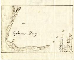
Gabarus Bay.
Coastal profile-style map of the bay where British troops landed in 1758 to besiege Louisbourg.; Table of references to main points of landing and French defenses.; Pasted to Wight, E. An exact ground plan of Fort Edward.
The University of Michigan Library provides access to these materials for educational and research purposes. These materials may be under copyright. If you decide to use any of these materials, you are responsible for making your own legal assessment and securing any necessary permission. If you have questions about the collection, please contact the William L. Clements Library: icwcl1ic-umdl-help@umich.edu. If you have concerns about the inclusion of an item in this collection, please contact Library IT: libraryit-info@umich.edu.